Nature in all its splendor Lava grottos of Simeto "U Bazu 'a Càntira" 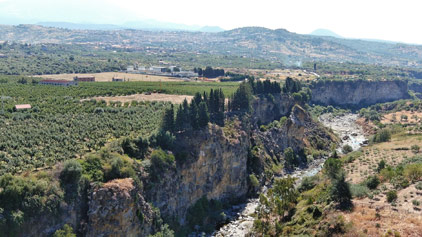 The integral nature reserve of the "Forre laviche del Simeto" (Simeto lava gorges) is a Site of Community Interest (identified with the code ITA070026), established in 2000 by the Ministry of the Environment with the aim of safeguarding and conserving natural and semi-natural habitats, as well as wild flora and fauna of the upper Simeto basin. The integral nature reserve of the "Forre laviche del Simeto" (Simeto lava gorges) is a Site of Community Interest (identified with the code ITA070026), established in 2000 by the Ministry of the Environment with the aim of safeguarding and conserving natural and semi-natural habitats, as well as wild flora and fauna of the upper Simeto basin.
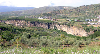
It falls on the western slope of Etna where the river, in the junction area between the southern slope of the Nèbrodi mountains and the Vulcano, at the foot of Bronte, has dug and eroded millenary lava flows forming, in the river stretch between the two bridges of Càntera and of Serravalle and the Saracen Bridge in Adrano, suggestive gorges and narrow ravines that constitute places that have never undergone interaction or modification by the hand of man, undoubtedly of significant environmental and landscape interest. The protected area, also implemented in 2005 by the Sicilian Region which approved the maps, extends into the municipalities of Bronte, Adrano and, partially, Centuripe and Randazzo, therefore affecting the two provinces of Catania and Enna. 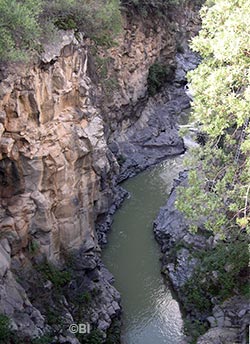 It has a territory of 1,217 hectares, of which 285 are in the maximum protection zone. The midpoint is located in the Bronte area north of Contrada Pietrerosse, in front of the Marotta and Barbaro districts. It has a territory of 1,217 hectares, of which 285 are in the maximum protection zone. The midpoint is located in the Bronte area north of Contrada Pietrerosse, in front of the Marotta and Barbaro districts.
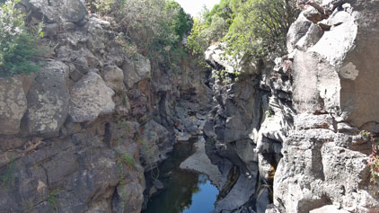
It concerns a strip of territory of particular interest and geological-environmental value both for its morphologies and ecosystems and for the microclimates that have stabilized there. It protects the entire stretch of the Alto Simeto, in which the most ancient Etna lavas, reaching the old course of the river, have crossed it several times and have then been dug and eroded by it with deep incisions, splendid gorges, caves, bends, waterfalls and lakes, which - set in the black basalt and the surrounding environment - create landscapes of rare beauty and charm. The management of the reserve has been entrusted to the State Forestry Company of Sicily.
Bronte' zone represents
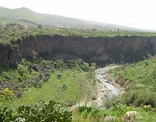
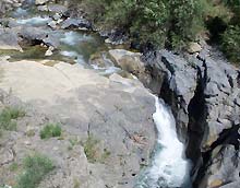
Bronte' zone represents the initial tract of the river, and surely, the wildest, where the waters play games of skill and acrobatics with the black lava, while the observer can look astonished at the power that this river, in spite of the enormous damages that our inexhaustible greed has inflicted to its life, continues to display. The morphologic, paleontologic, biologic and aesthetic characteristics of the area retain, nearly unaltered, their natural charm, lit up and re-invigorated by particular fauna and flora components and by the constant presence, on the horizon, of the snowy cone of Etna. 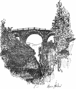 In particular, the nature reserve is characterized by the typical appearance of the Simeto, with a large alluvial mattress of debris coming mainly from the Nebrodi, from the lava gorges very similar to the famous Alcantara gorges and from the high lava walls that wind to the left of the river for over five kilometres, with columnar basalt formations, jumps, rapids and waterfalls, lakes and white foam waters. In particular, the nature reserve is characterized by the typical appearance of the Simeto, with a large alluvial mattress of debris coming mainly from the Nebrodi, from the lava gorges very similar to the famous Alcantara gorges and from the high lava walls that wind to the left of the river for over five kilometres, with columnar basalt formations, jumps, rapids and waterfalls, lakes and white foam waters.
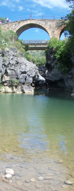
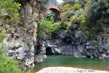
The gorges have walls of variable height and width: the height varies between 10 and over 50 metres, the width between 5 and 20 meters of distance between the erosion banks. They are covered, especially in the spring season, by vegetation typical of the so-called Mediterranean scrub such as wild olive, holm oak, hackberry, prickly pear plants, capable of surviving the floods and heat of summer, but also the winter frost, hosting very rare fauna. Under the Cantera bridge and the Norman bridge of Serravalle district (on the right in an ink drawing by Mario Schilirò), the Simeto and the Troina meet high basaltic lava walls, they go over them with a sequel of jumps, rapids and water games, penetrating first with a very narrow duct and a millpond of a few square meters, but mounted between high basaltic walls, to join together, further down, in an uncontaminated scenery.
Other important historic testimonies
 Some important historical testimonies are part of the area affected by the reserve. Some important historical testimonies are part of the area affected by the reserve.
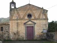
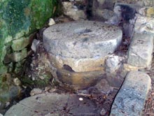
In addition to the two bridges over the Simeto and the Troina, we mention the Arab paper mill of Ricchisgia, the ancient Casale di Placa Baiana, a Sicilian farmhouse with an adjoining water mill located at river level, built in the mid-1800s a few steps from the bridge over the Troina by Baron Francesco Serravalle, once owner of the lands in this part of the Placa, and a small rural church which, even today, offer glimpses of past life and bucolic panoramas.
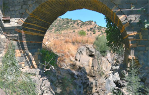
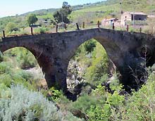
The small church of Serravalle, dedicated to San Francesco di Paola, characterized by a singular tricuspid tympanum and three pointed arches drawn into the wall, was built in 1850; today, abandoned, it is used as an agricultural warehouse. The Càntera bridge under which the Forre begins is of Norman origin: it was built by Count Ruggiero II "the Norman" in 1121 in memory of his mother Adelasia, who died in Patti in 1118. The ancient important road passed there which, protected by the castles of Bolo and Torremuzza, connected the hinterland of Sicily (the Norman capital Troina, Cesarò, Nicosia) to the eastern coast of Sicily. Traveling along this road today by car (it is provincial road 17iii), the bridge and the ravines below are barely visible and almost imperceptible; you have to stop and look out from the high parapets to admire the incredible hidden scenery. Continuing on the road in front of the ancient farmhouse which climbs up Mount Reitano ('a Praca, 1,080 m.), a breathtaking panorama opens up of the great valley of Etna and Bronte, from Maletto to Adrano and down to the Forre del Simeto.
The lava ravine is a very deep cut
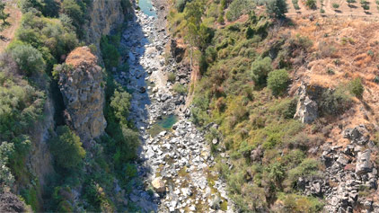 The lava ravine is a very deep cut, dug during millenniums by the Simeto river between the lava of Etna and the sedimentary ground of the mounts of Bronte's valley. Offers a mini-environment unique, harsh and wild, but also very suggestive and uncontaminated. The lava ravine is a very deep cut, dug during millenniums by the Simeto river between the lava of Etna and the sedimentary ground of the mounts of Bronte's valley. Offers a mini-environment unique, harsh and wild, but also very suggestive and uncontaminated.
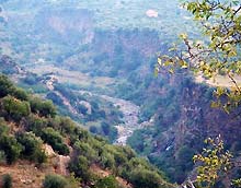
The photographs on this page only partially illustrate the beauty of the places and the majesty of this still almost untouched site; in the video below on the right ("Let's go inside the gorges") our camera entered the gorges better, showing them in all their majesty even from above. The lava of ancient eruptions that filled the original bed of the river, has been, in millennia, eroded and deeply dug down in a profound ravine, very narrow and with nearly vertical smooth lava walls.
From the two bridges Cantera and Serravalle, put in the homonymous areas, close to Bronte and easily to drive to, is possible to see the erosion's initial part. It is a cliff and a wild ravine, called by the folks of Bronte "u bazu ‘a cantira" (the leap of the Cantera), where, under the bridges of Cantera and Serravalle, the Simeto and Troina rivers fall foaming over the lava over the sandstone blocks.
The Norman bridge
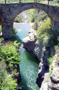 The Norman bridge across the river, a very daring piece of work composed by hydrodynamic piers that hold medieval arcades of a humpbacked bridge, is characterized by the use of local basaltic stones, alternating to ashlars of white tuff, with a chromatic effect truly particular. The Norman bridge across the river, a very daring piece of work composed by hydrodynamic piers that hold medieval arcades of a humpbacked bridge, is characterized by the use of local basaltic stones, alternating to ashlars of white tuff, with a chromatic effect truly particular.
The ancient important communication route passed over the bridge which, protected by the castles of Bolo and Torremuzza, linked the hinterland of Sicily (the Norman capital Troina, Cesarò, Nicosia) to the eastern coast of Sicily (Catania, Messina). Several times the bridge was destroyed by the fury of the Troina river; the last renovation dates back to 1899 as engraved on the capstone of the western arch. Then, on 15 September 1948, a violent storm caused the river level to rise by about ten metres, which flooded the ancient Sicilian baglio and ruined the bridge, depriving it of its original parapets and making it impassable. And since then it has remained so, degrading itself more and more amidst general indifference. The oldest image is a drawing made in 1842 by the famous German geologist and astronomer Wolfgang Sartorius of Waltershausen entitled "View of Etna taken from the Serravalle Bridge near Bronte". Today it is in a state of total abandonment, degradation and even extreme danger. Under the bridge, a crack steep and impracticable, initially few meters wide and deep, between eighty and one hundred meters high, squeezed between colored basalt walls, enlarges then, for kilometers, luxuriant of vegetation and animal life, among majestic basalt walls. The photographs on the page only partially convey the beauty of the places and the majesty of a site that is still almost untouched; in the video on the right our camera enters the gorges showing them to you in all their majesty.
Going down along the river
 Going down along the river, in several points, are particularly interesting the formations of polygonal lava, or basalt colonnade, due to the sudden cooling of the lava flow in contact to the Simeto waters, the ample lava terraces that testify the expansion of the volcanic edifice over the territories occupied before by sedimentary outcrop and the typical vegetation that assumes particular features with the Oleander presence, the bush euphorbia, able to grow and branch out over the lava. Going down along the river, in several points, are particularly interesting the formations of polygonal lava, or basalt colonnade, due to the sudden cooling of the lava flow in contact to the Simeto waters, the ample lava terraces that testify the expansion of the volcanic edifice over the territories occupied before by sedimentary outcrop and the typical vegetation that assumes particular features with the Oleander presence, the bush euphorbia, able to grow and branch out over the lava.
Over the river gravel bank can be found the inundations constituted both by pebbles of lava, of various color, and by sands, gravel and pebbles of sedimentary origin coming down exactly from the Nebrodi. It is not rare to find amber' pebbles and shells, light-colored that always attract the searchers and that tell us of a far geologic past. The large stony riverbed is often occupied by typical river bank vegetation: canes and oleanders that in spring assume a magnificent blooming. The agricultural landscape is typical of Bronte, with old zones often subjected to floods, changed in fruit orchards, with the very stony ground where the Bronte's farmer has planted vast Pistachio cultivations, and, in some spots, occupied by grazing land steep and degraded, that among the grass cover, the clayey soil characteristics, with large groves, narrow and deep and with steep ridges towards the tops. Around a contrasted landscape and a deeply varied nature, aized tree cultivations that go from the fruit orchards (pears, peaches, etc.) to the clayey pastures alternating with steep lava fields cultivated to pistachio, citrus fruit orchards, olive or almond trees, vegetables, prickly pears, wheat and cereal fields. The fauna component of this ecosystem comprises some reptiles (The collar snake, the viper snake, the leopard snake, maybe the best looking European snake long up to one meter), the lizards (Ramarro, Lacerta viridis o la Podarcis sicula) that hide among the vegetation or among stones and rocks, some amphibious rare species (the Discoglosso), some frogs and toads that live near the river (Bufo bufo spinosus and Bufo viridis) Rare and nearly absolutely absent the fish fauna. | 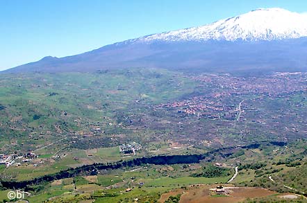
 established by regional laws n. 98 of 6 May 1981 and n. 14 of 9 August 1988 and approved by decree of the Department of Territory and Environment of 10 June 1991.
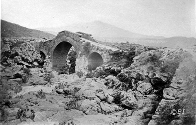 The Serravalle bridge (on the right in a photo from 1880, before the reconstruction in 1899), located on the Troina river, a hundred meters before its confluence with the Simeto, takes its name from Baron Francesco Serravalle, owner of the lands of this part of Placa.
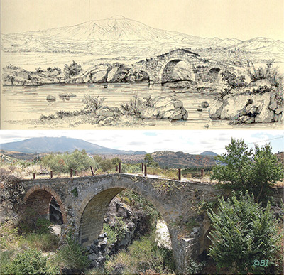 For several centuries, Serravalle was therefore the only access road for the people of Bronte to the Placa districts. The other bridge (the Passopaglia) was built, about 6 kilometers further down, in front of the S. Cristoforo valley, only in 1930.
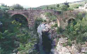 For the safeguard, the conservation and the protection of the particular environmental value of the lava grottoes, of the waterfalls and the small lakes created by the Simeto and of the typical vegetation of the river's banks and also of the specialized fauna component that lives in the zone, there are regional safeguard laws.